Clearing some stuff out recently I came across a couple of old guidebooks - Pennine Way South and North - the entire route split down into sections. Oh yeah I thought, I was going to do that when I had time. After a short think over a cup of coffee at a friend's house one morning, I'd convinced myself to give it a go. I was in England, had nothing to do for several weeks, and the Olympics was about to start. Perfect timing for getting lost :-) So I booked a train ticket to the start at Edale and threw a few essentials together, buying a rucsac to hold my stuff. Arriving at Edale on Thursday 26th July, I gave myself two weeks to try to complete the trek. These are my notes.
Day 1 - Edale to Crowden YHA (Derbyshire) 16 miles
 |
| Me looking over Torside Reservoir |
Left beautiful Edale at 8.30am thanks to a timely arrival at the visitor information centre the previous evening - three minutes to closing - so I could buy a map case whilst the nice lady kept looking at her watch. Waiting for the place to open at 9.30am would have made for a longer first day walking. Climbing out of the valley I almost immediately passed a father and son team on the same schedule as me... they'd allowed two weeks too. Their rucsacs were huge compared to mine and I started to fret I'd under planned as usual. Mick and his son Charlie seemed confident and I said I'd see them later in the day, or at Crowden. ALL walkers talk about the haul up Jacobs Ladder to Kinder Low, it is infamous, so I was surprised and happy when I'd summited Kinder Low by 9.30 and pressed on over the peaty plateau in the mist.
The Way follows the edge of the Kinder plateau and it was windy so the mist cleared and the sun came out. After passing over boggy moorland and crossing the A57 at Snake Pass, where sadly there were no more than one or two parked cars (no burger vans as I had been hoping). Passing a few people on day walks, I pushed on - the climb up Bleaklow complicated by winding up through peat groughs, criss crossing peaty red streams. The summit was more peat, very bleak and aptly named. Despite a lack of signs on the descent it was much easier to follow the path, which stuck with one large grough until it opened out to reveal Torside reservoir in the valley below. It was at this point I realised I'd been walking without a pause so I made myself sit and eat an energy bar in the sunshine, with the valley spread out before me. The only noise was the wind.
High on one side of the ever widening grough, I descended on tired jelly legs towards the reservoir, crossing the dam as Crowden was on the far shore. I finally got to the Youth Hostel just after 4pm and found it didn't open until 5, but twenty minutes or so later another walker called Mark showed up and we had a chat... he'd left Edale about an hour after me and was planning to do the whole Way in 14 days too. We both managed to get a dormitory to ourselves as the hostel was more or less empty, and when Mick and Charlie showed up we had dinner and a few beers together.
Day 2 - Crowden to Mankinholes YHA (W Yorkshire) 21 miles
 |
| Stoodley Pike, near Mankinholes |
I had a descent sized breakfast - cereal, bacon, egg, sausage, beans and as much toast as I could fit down me, discussing plans with Mark and Mick. Mick had booked himself and Charlie into Mankinholes YHA but after struggling with 16 miles the first day he knew 21 was too much, so he very kindly passed the booking over to me. Mark had booked into the YHA too and I figured I would see him there. Mick thought they might make Standedge so I said my goodbyes and wished them well. Heading out of Crowden alone in my full wet weather gear, I started the long, arduous climb up the valley. The rain slackened and I removed my waterproof pants, glancing behind I couldn't see anyone down the valley and I wondered what had happened to Mark, he was still at the YHA when I left. Ahead, climbing hard I could see two rucsac laden figures. Gaining the top of the valley it started to rain quite heavily, and slogging across the peaty moor towards the summit of Black Hill was a miserable experience. Black Hill summit, again aptly named, was very dark and bleak. The weather cleared and as I dropped towards the A635 I could see "Snoopy's" snack van - referenced in my 20 year old guidebook - and started to think about doughnuts and coffee. I was also going to catch up to the two figures in front of me. I arrived at the van, and there was Mark! He had picked up a hot tip on a shortcut out of the hostel and shaved 20 minutes off the official route :-) He'd met Vanessa who was also at the hostel the previous night.
After a coffee (no doughnuts. Bah) the three of us set off through the moors and reservoirs. Lunch was at Standedge overlooking Mark's house in saddleworth. We were ridiculing Vanessa for her tiny 15 litre sack which contained among other things study books and shoe polish (!!) But she was an accomplished walker and planned to do all 260 miles in 10 days. Eventually the path became a broad hard track past reservoirs which was easy to follow but murder on my feet. Within sight of Stoodley Pike, a memorial to the end of the Napoleonic war, we turned down off the trail to Mankinholes at about 6.30pm...long day but not over for Vanessa. She decided to press on for a few more hours! We said our goodbyes and wished her luck, then Mark and I hit the pub and sank some Black Sheep ale which didn't quite alleviate the foot pain. Two blisters on my right foot and more worryingly, sharp pain in both knees. Hmmm.
Day 3 - Mankinholes to Cowling (N Yorkshire) 20 miles
 |
| Double arched bridge, Leeds/Liverpool canal |
The day had promised to start nastily as we had to climb back up to the Pennine way from the YHA, but we'd done that in twenty minutes and were walking along a ridge line towards Stoodley Pike in the wind and rain. The monument itself was a massive stone affair with grafitti dating back more than a century, the elegant carving of Victorian vandals somehow more pleasant than the recent spray painted stuff. Pressing on the most unpleasant part of the trail came after we crossed the Rochdale canal and climbed a steep hill, slick wet flagstones making it hard going but the long wet grass and ferns soaked us just as effectively as if we'd gone swimming in the canal. My feet started to squelch and I realised water had soaked my socks and then flooded my boots.
We trudged into Colden in the rain and got a little lost looking for the path - bumping into another Wayfarer going the wrong way didn't help us - before Mark figured out where we were. There was a Farm shop so the three of us went and got sandwiches for later and as we'd not eaten breakfast, Mark and I had a distinctly lukewarm pie. We left the other chap, John, sipping tea and pressed on. The Way seemed to follow a pattern of ascending small hills and dropping into valleys for the rest of the afternoon, the wet weather eventually easing. When we eventually came in sight of Cowling it was deceptive as the path seemed to zigzag above the small town for miles before crossing some boggy fields and depositing us right by the b&b Mark was booked in. Happily they had a spare room and after taking care of my feet, which were white and puffy after the soaking they got, we had a huge Indian meal. The landlady at the b&b told us stories about a man that did the Way 13 times, and another guy that completed it then turned straight around and walked back all 260 miles. Nutter.
 |
| Malham, with Malham Cove behind |
After hauling a 20 pound pack up hill and down dale 8 hours a day for several days, my knees were grateful for an easier day. It started with more ups and downs until we got to Thornton-in-Craven. Suddenly the Way began following the Leeds/Liverpool canal and it was picturesque, easy walking. We found a coffee shop next to a big Stables and ordered sandwiches, caramel shortbread and to my great and lasting delight a decent latte to go. At Gargrave we sat by the river Aire in the warm sun and ate our lunch, chatting about upcoming sections of the walk. From there the Pennine way followed the Aire all the way into Malham, passing livestock and fields full of buttercups (as well as the trademark fields full of mud). Malham cove looked daunting as it came into sight but as Mark pointed out, it was tomorrow's problem :-)
Day 5 - Malham to Horton-in-Ribblesdale (Yorkshire Dales) 14 miles
Woke with stiff knees and unlike previous days the pain wouldn't shift... I took ibuprofen but immediately after we left the YHA we climbed Malham Cove and the sharp ascent gave my knees a battering. To make things worse we then went past Malham Tarn - the Canada Geese made me smile - and up over Fountains Fell. The ascent was OK but I could barely descend the far side at all... Mark was having to wait for me more and more often. As we dropped into the valley below and the looming mass of Pen-y-ghent, one of the bigger peaks on the whole walk, got closer I started to worry I wouldn't make Horton, let alone the end of the Way.
We cut around to the shoulder of Pen-y-ghent and then right before the main climb we had lunch on the upper slopes. I took more painkillers and then we went for it, gaining the summit in about 15 minutes of hard work. The last little scramble was rather fun, but then we had a three mile descent into Horton which again killed my knee.
We found Pen-y-ghent cafe and Tourist Info shut for the day but the Golden Lion had rooms - sadly without hot water and although the pub had wifi the staff didn't have any idea what the password was, It could only happen in the UK :-)
Day 6 - Horton to Hawes YHA (Yorkshire Dales) 14 miles
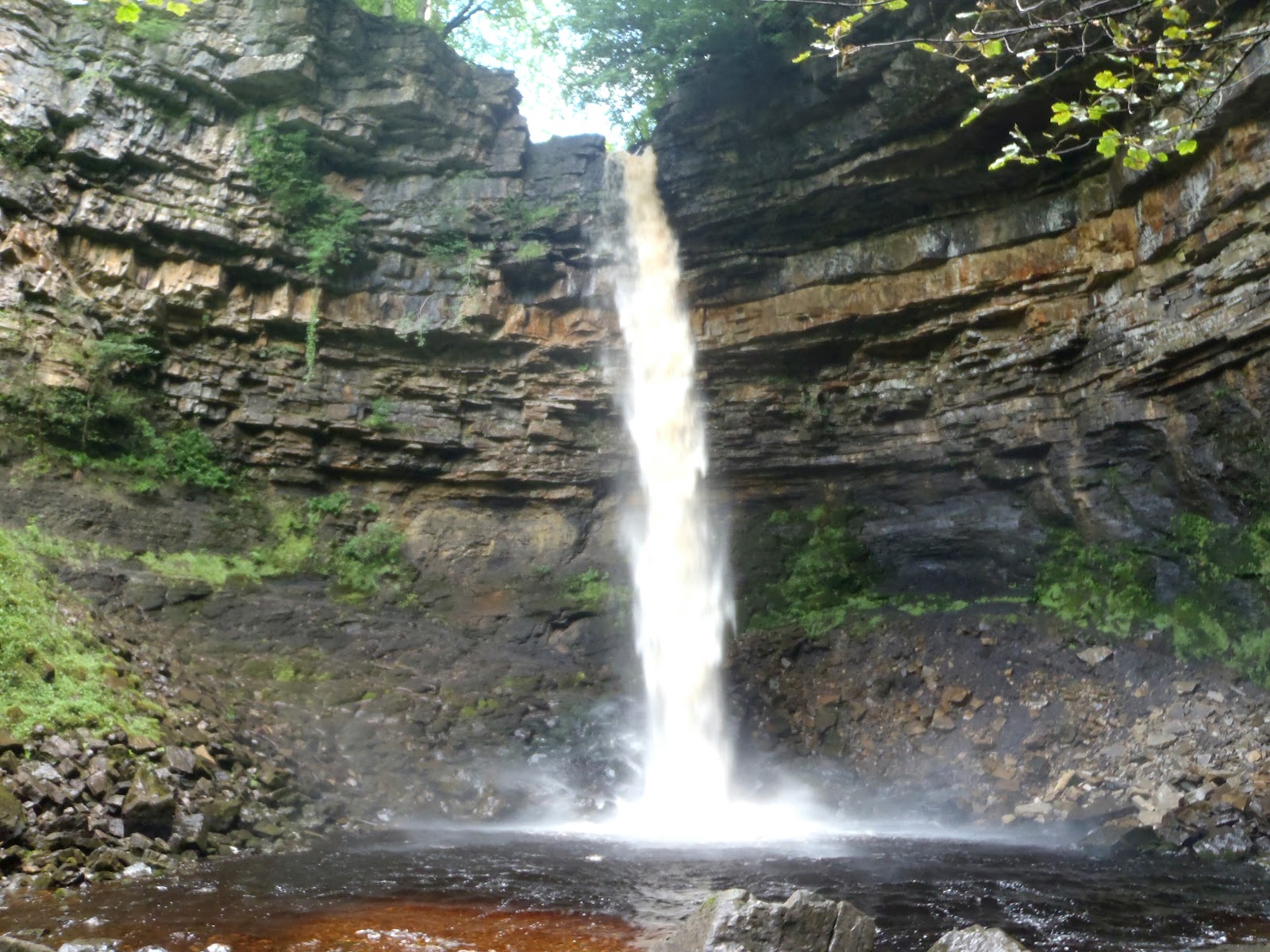 |
| Hardraw Force |
We crossed Cam Fell and Dod Fell without issue and looking at the map I realised we'd be finished and in Hawes by mid afternoon. That seemed like a good thing as the weather appeared to be chasing us over the fells - we'd been lucky with the lack of rain for several days but it looked like it was about to really let fly. Coming down into the outlying farms and area around Hawes, Davinder got excited as for the first time on the Way he was going to be inside the time his guidebook quoted for a stage... that excitement turned to annoyance as it looked like we were going to get a soaking five minutes from shelter. We pretty much ran the last handful of yards off the official trail and into the White Hart Inn as the rain came down. From there we went to the Crown and after a few pints of Old Peculier on an empty stomach I wasn't in a good way :-)
After an expensive trip to the pharmacy - knee supports, foot cream and painkillers - we went to the outdoor shop and I bought walking poles and insoles for my boots. Then it was back to the Crown for an evening with Davinder and Lee, Mel and Simon who had been camping at Malham and Horton.
Day 7 - Hawes to Tan Hill inn (Yorkshire Dales) 17 miles
 |
| Tan Hill Inn, surrounding desolate moor not shown :-) |
From Thwaite the Way rises over Kisdon Hill to Keld, the sun was out and the views were the best I'd enjoyed so far. Lots of people were out on day trips from Thwaite or Muker. Stopping at Kisdon Force I noticed the rain clouds coming down the valley so I passed Keld quickly and picked up the pace for the haul up to Tan Hill inn, Britain's highest pub, enjoying the cardio workout. I wandered into the bar at about 5.30pm and a family chuckled about how tired I looked. After a pint of Old Peculier Davinder came into the bar, he'd been there since mid afternoon. He was having fun talking to the landlady, who was a female Basil Fawlty, pretty much all she needed was the moustache. Having had a few beers I was in full on shout at the TV mode as the French team made their slalom canoe run in the Olympics, when it became apparent they wouldn't beat the British team I laughed 'go home Frenchies' - only to discover the barman was French. He took it in good spirit, although I spent the rest of the evening inspecting my beers for spit.
Part 2 in short order....
Frase.